
Halfway picks in the public domain
Shown in his water flood application
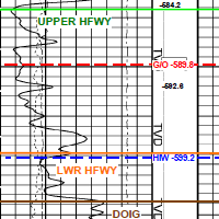 While applying for a water flood approval, this applicant also submitted his net pay map, structure map and type log with his formation picks. He showed his well density and stated his reserves. For the astute offsetting exploration geologist, this is huge competitive information.
Each AER application contains your neighbor's perspective on the exploitation of oil and gas formations. Applications contain more technical data even than SPE papers.
Would you like to see what other operators in your areas are thinking about seismic, multifractured wells, polymer schemes and recovery? AppIntel can help.
Subscribers can view this application by pasting the following link into their browser after logging into AppIntel. app.appintel.info/AOW.php?pxnrg=55756n383332353o3231374v49
Tags: Seismic, Flood, Exploration
 Granger Low 14 Sep 2015


Injecting steam and flue gas into heavy oil
Capture Carbon. Improve Recovery.

Can we save the world by sequestering CO2?
Plans to store millions of tons of CO2

Save the world by recycling produced brine
Saline water treatment

AppIntel AI: Work smarter, not harder
Those that can't see the value of a car should walk
 Calgary, Alberta, Canada
 Share
Share